Software Screenshot:
Software Details:
Version: 1.01
Upload Date: 22 Jan 15
Developer: Dimitrios Mitropoulos
Distribution Type: Freeware
Downloads: 91
Size: 92 Kb
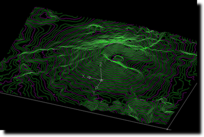
Topo Launcher is a CAD tool for importing-exporting field survey points, constructing Triangular Irregular Network (TIN), Contour Lines, Cross Sections, along with various tools for modifying and survey drawings. It features a series of CAD tools that enables processing of digital landscape, cross-sections and contour lines for land survey works. It includes draw a scaled grid for plan plotting, import points from ASCII (simple text) 3D coordinate file, export coordinates to ASCII in Cartesian or polar coordinate system, produce a cross section of the landscape, produce analytical area calculations and draw calculation formulas on drawing, and produce contour lines of the site.
Requirements:
AutoCAD 2000 or later, VBA
Comments not found