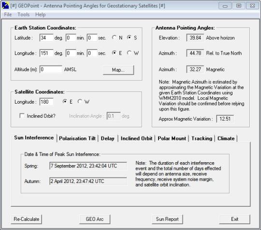
GEOPoint is an easy to use satellite antenna pointing calculator, for geostationary communications satellites. The program also calculates polarization tilt angles, estimates dates and times of annual sun-outage events, calculates antenna G/T, eirp and frequency stability, and estimates path-loss and rain-attenuation based on ITU-R climate models. Features include an easy to use dialog-style user interface for data entry and calculation, entry of earth station location coordinates directly, or by clicking on a world map, select earth station location from a built-in list of world major cities, display of satellite elevation contours on the world map to aid in site selection, entry of latitude and longitude coordinates in D, M, or S format, or as decimal degrees, calculation of pointing angles to a specified satellite for common types of antenna mount, display of azimuth pointing angles relative to true North and relative to local magnetic north, estimation of antenna movement limits for inclined orbit satellites, calculation of polarization tilt angle, loop-back path delay, and required antenna tracking speeds, estimation of the peak dates and times for sun-interference on the receive link, and output of a summary report in HTML format.
What is new in this release:
Version 3.05 has fixed rounding error where a decimal degrees conversion to D,M,S sometimes resulted in a value of 60 in the minutes box.
Comments not found