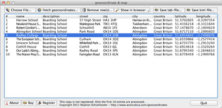
In google-maps, you can create your own maps displaying several placemaks with additional information. You may manually create placemarks in google-maps, but that might be a lot of work, if you have thousands of adresses to be displayed. For example, if you like to show all Fast-Food restaurants in the U.S.A. geocoordinate & map uses your address lists and saves them as kml-files, which are used by the google-api for displaying the placemakrs in a google-map. The google-map api only accepts kml-files holding the corrsponding geodata (latitude and longitude) to an address. Therefore geocoordinate & map first retrieves the corresponding geodata (latitude and longitude) to the addresse also using the google api. Since geocoordinate & map also exports plain tab-delimited text-files you may use the geo-information in many other navigation software products.
What is new in this release:
Added support for google Maps API3
Limitations:
10-adresse trial
Comments not found