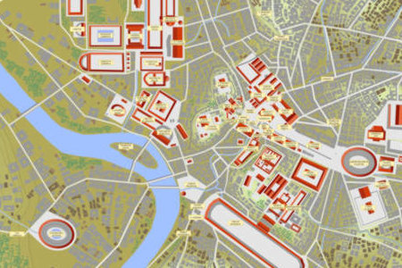
A vector map of ancient Rome in year 100 AD, in Corel Draw 10 and Adobe Illustrator 8 format, with contour lines, public and private buildings, roads, woods, gardens, and labels. The map allows the display of the Seven Hills only with the prehistoric villages existing before the emergence of the city. The map consists of 40 layers or planes which surimposing order, names, fonts, and colors can be changed according to user's choice. 1) & 2) flumen: blue ground layer + solum: ground plane in which the river Tiber is drawn. 3 to 25) 23 contour lines with an approximate interval of 2.5 meters. 26) aquulae: small rivers. 27) & 28) romulus: the seven original villages, ~8th century BC. + fora: public squares of Rome in year 100. 29) & 30) pontes: bridges over the Tiber in year 100. + viae: roads and streets in year 100. 31) & 32) aquaeductus: the aqueduct Aqua Claudia. + domus: buildings in brick, concrete or wood. 33) & 34) tectatempla: tile roofs of public buildings and temples. + servius: the so-called Servian Wall built ~4th cent. BC. 35) & 36) horti: gardens and woods. + scripta: Latin labels for the public buildings and temples. 37) & 38) colliscripta: Latin labels for the Seven Hills. + regiones: Latin labels for the Augustan districts. 39) & 40) indexbrit: title block in English. + indexfran: title block in French. Layers 27 and 37 have to be used independently of layers 28 to 36 in order to display the Roman campaign before the emergence of Rome. Layer 38 cannot be used together with layer 36 unless the names are moved. This vector map is provided with its English and French licence, with a detailed description of the layers and with a short tutorial on how to simulate depth with Corel Draw or Adobe Illustrator.
Requirements:
CorelDraw 10 or Adobe Illustrator 8
Limitations:
Excerpt of the full map only
Comments not found