Software Screenshot:
Software Details:
Version: 1.0
Upload Date: 4 May 15
Developer: Euratlas Nussli
Distribution Type: Shareware
Price: 21.71 $
Downloads: 13
Size: 359 Kb
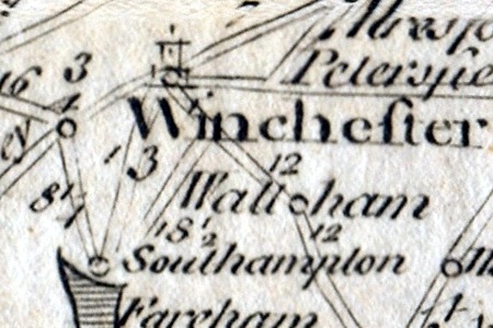
This is a digital copy of an antique print from the 'Modern Universal British Traveller' showing the post-roads of England and Wales in the 18th century with distances in miles. The original title cartouche reads: A New & Most Accurate Map of the Roads of England and Wales with the Distances by the Milestones, and Other Most Exact Admensurations Between Town and Town. Main Features: - 1 digital map of England and Wales in JPG and PNG format. - Size of 8304 x 8224 pixels. - Real size, same as the original: 35 cm x 35 cm.
Limitations:
Low resolution only


Comments not found