Software Screenshot:
Software Details:
Version: 4.4.2
Upload Date: 1 Jan 15
Developer: Sandy Knoll Software
Distribution Type: Shareware
Price: 29.95 $
Downloads: 29
Size: 23827 Kb
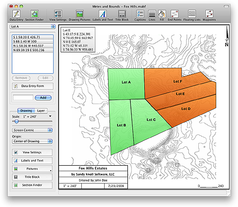
With Metes and Bounds, turn Metes and Bounds data into a plot map. Perform calculations such as square footage or acres. It includes auto-completion for those incomplete surveys. Enter measurements in feet, meters, and rods. It supports curves, multiple layers, and GPS waypoints. Metes and Bounds will calculate if the survey closes or not. Features include auto-completion of drawing, multiple measurement types, layers, automatic labeling, create custom labels and backgrounds, background pictures, and split a single plot into multiple plots.
What is new in this release:
Version 4.4.2 fixed issues where with pops up on extra messages when doing certian Lat/Long calculations and title block style error.
Limitations:
Some features limited

Comments not found