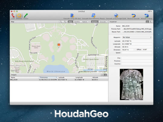
HoudahGeo will let you know where you took that photo. HoudahGeo is a photo geocoding & geotagging solution made for Mac OS X. It 'pins' photos to locations where they were taken. Just like a GPS-enabled camera, HoudahGeo can store latitude, longitude and altitude information right within the image file. HoudahGeo writes industry standard EXIF, XMP and IPTC tags to JPEG and RAW images without recompression or loss of quality.
HoudahGeo is tightly integrated with Apple iPhoto and Aperture. It can also access images in your Apple Photos library and Adobe Lightroom catalog. HoudahGeo caters to two very different needs: geotagging for archival purposes using EXIF, XMP and IPTC tags, geocoding for publishing to Google Earth or Flickr. HoudahGeo can publish GPS tracks and photos to Google Earth: see your photos in context along the path you travelled.
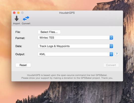
Geotagging is essential for professionals who need to know and show where photos were taken. It really shines when documenting travel. Image a Safari. Animals roaming in the middle of nowhere. Driving all day to capture the best moments. Return home and see a birds-eye view of your journey. Locate the exact tree that leopard was perched in. HoudahGeo offers you many ways of geocoding your favorite photos: automatic: matches photos to GPS track logs and waypoints. GPX, NMEA, Sony LOG, Wintec TES; iPhone / iPad: matches photos to reference photos taken using iPhone. Using a map: Pick locations using the built-in maps. Using Google Earth: Point to the desired location. Precision: Attach photos to GPS waypoints. Manual: Enter coordinates found on Google Earth, Wikipedia.
What is new in this release:
- Works around a problem where Lightroom failed to pick up altitude and direction values
- Fixes a possible crash after closing a project window
- Corrections to the German localization
What is new in version 5.1.2:
- Added a "File Extension" column to the list of images
- Creation of XMP sidecars could fail when working with RAW+JPEG pairs
- Camera import could get interrupted when plugging in a second camera or memory card
- Google Earth export created an invalid KML file when file names contained the "&" symbol
What is new in version 5.1:
- HoudahGeo can now add locations to photos in your Apple Photos library. This requires Photos 2.0 on macOS 10.12 Sierra
- On macOS 10.12 Sierra, HoudahGeo now offers Apple Maps in addition to MapBox maps
- Improved camera setup options. HoudahGeo now assumes that timestamps that already include time zone information are correct and need no further adjustments
- Changes the color of track logs from blue to red for it to better stand out on various terrains
- Fixes a bug that could cause photo import to hang
- Fixes several minor bugs throughout HoudahGeo
What is new in version 5.0.9:
- Fixes a problem with importing images from Apple Photos
- Fixes a bug that could prevent project files from being saved
Users of of macOS 10.12 Sierra, should give the beta of HoudahGeo 5.1 a try. This adds the ability to notify the new Apple Photos 2.0 of changes made to location information.
What is new in version 5.0.8:
- Improved performance of EXIF / XMP export
- Compatibility fix for GPS devices based on SkyTraq chipsets
What is new in version 5.0.4:
- Accepts metadata from non-standard EXIF in Panasonic RW2 files
- Fixes a problem where HoudahGeo assumed an incorrect time zone when camera used stale GPS data
- Fixes a problem where Mac OS X Gatekeeper reported HoudahGeo to be damaged
What is new in version 4.2.5:
- Bug fix: Photos rotated in Lightroom were not displayed correctly in HoudahGeo
What is new in version 4.2.3:
- Enhancement: Added heading and viewing direction to CSV export
- Bug fix: Fixes a bug where viewing direction was not shown in Google Earth
What is new in version 4.2:
- Bug fix: iPhoto libraries on external drives Fixes a problem causing excessive resource usage when loading iPhoto libraries located on external drives
- Bug fix: GPS devices Fixes a bug which could prevent HoudahGeo from detecting newly connected USB devices
- Enhancement: Image selection When removing an image from a project, HoudahGeo now selects the next image in the list
- Enhancement: Document saving HoudahGeo now finalizes text field edits before saving a project file
- Enhancement: Image selection Includes a workaround for a bug where Google Earth fails to reveal the requested location
What is new in version 4.0.1:
- Bug fix: iPhoto libraries on external drives Fixes a problem causing excessive resource usage when loading iPhoto libraries located on external drives
- Bug fix: GPS devices Fixes a bug which could prevent HoudahGeo from detecting newly connected USB devices
- Enhancement: Image selection When removing an image from a project, HoudahGeo now selects the next image in the list
- Enhancement: Document saving HoudahGeo now finalizes text field edits before saving a project file
- Enhancement: Image selection Includes a workaround for a bug where Google Earth fails to reveal the requested location
What is new in version 4.0:
Adds compatibility with Mac OS X 10.9.5 and Mac OS X 10.10 Yosemite
Requirements:
Digital camera, optional GPS track logger
Limitations:
5 images per export
Comments not found