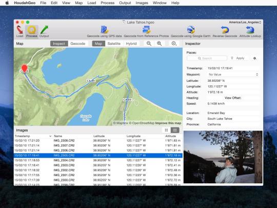
HoudahGeo is a photo geocoding and geotagging tool. Use HoudahGeo to attach GPS coordinates and location names to your photos. Location information adds to the "story" of a photo. A photo pinned to a map has context. A series of tagged photos documents the path taken. Unfortunately, many digital cameras still lack GPS receivers. This is where HoudahGeo steps in. HoudahGeo tags digital photos with GPS location information. HoudahGeo writes future-proof EXIF and XMP tags to JPEG and RAW image files. Just like a GPS-enabled camera.
HoudahGeo adds geotags to JPEG and RAW image files. This creates a permanent record of where a photo was taken. Just like a GPS-enabled camera. Industry-standard EXIF, XMP, and IPTC geotags allow photo cataloging tools to organize and find photos by location. Geotagging with HoudahGeo follows an easy 3-step workflow: Load, Process, then Output.
What is new in this release:
- Reads temperature information from UDDF dive log files
- Fixes a couple of minor problems
What is new in version 5.2.3:
- Updated for compatibility with macOS 10.14 Mojave
- On macOS 10.14 Mojave, HoudahGeo now requests your permission to access the Photos library
- On macOS 10.14 Mojave, HoudahGeo now requests your permission to access interact with Photos, Google Earth, iPhoto and Aperture
- The HoudahGeo project window now fits a 13" retina display without overlapping with the Dock
- Fixes an issue where the Photos library browser failed to show album icons
Comments not found