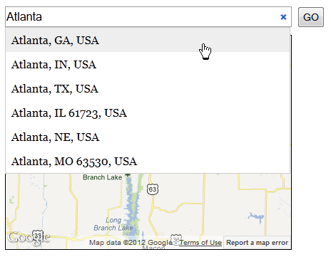
Software Screenshot:
Software Details:
Version: 6.1.0 updated
Upload Date: 9 Feb 16
Developer: Jean-Baptiste Demonte
Distribution Type: Freeware
Downloads: 69
The GMap3 plugin works with the latest version of the Google Maps API (v3), and allows developers to use every functions that the API supports.
This means support for overlays, markers, various map types, StreetView, layering, KML, and so on.
Lots of GMap3 examples are provided, along with in-depth usage instructions.
GMap3 also works with Prototype.
What is new in this release:
- Fixed some errors, missing declaration
- Code optimization
- New build system based on Gulp.js
What is new in version 6.0.0:
- Fixed some errors, missing declaration
- Code optimization
- New build system based on Gulp.js
What is new in version 5.0:
- Latest features :
- Tags
- Get / clear
- imageMapType
- Clustering
What is new in version 4.1:
- Fixed : getDistance, autoFit, destroy, clustering on zoom < 2
- Added : maxZoom added in autofit and in the clustering function
- Added : repeat getAddress on OVER_QUERY_LIMIT
- Updated : addMarkers can now use address resolution
- Updated : multi DirectionRenderer allowed
What is new in version 4.0:
- Code rewritten
- Updated: clusters : options can now be defined (allow to change pane, ...)
- Updated: clustering function now adds 2 overlays : the image and the shadow - it allows to get the mouse events even if the pane is changed
- New: add getDistance (use DistanceMatrixService)
- New: add classes into default setting in order to allow to redefine the used classes into gmap3
- New: add a repost on OVER_QUERY_LIMIT on address resolution
What is new in version 3.4:
- Updated:
- Compatibility with other libraries (Prototype...)
- Clustering function optimized
- addOverlay manage events (rightclick, dblclick, click, mouseover, mousemove, mouseout, mouseup, mousedown) (notice clusters are overlays)
- Added:
- getDOMElement function in addOverlays
- addMarkers accept custom data for each marker
- Fixed:
- addKMLLayer now stored (usable through get/clear)
- addOverlay now initialize the map
What is new in version 3.3:
- Added
- Autofit feature.
- Tag managed in addMarkers.
- Fixed:
- Get using tags.
- Updated:
- List renamed as name in clear function.
What is new in version 3.2:
- Clustering function rewrited to be faster and cleaner
- Clustering renderer now use marker options for alone markers
- Add a tag parameter to identify objects using get or clear functions
- getaddress now can take GeocoderRequest or string in address parameter (allow to create autocomplete address field)
- Callback position moved to global object (backward compatibility)
- Deprecated functions removed (removedirectionsrenderer, removetrafficlayer, removebicyclinglayer)
- addtrafficlayer and addbicyclinglayer fixed (callback usable...)
- Clear fixed for internal use
What is new in version 3.1:
- Integration to jQuery updated (all CSS accessors usable now).
- Callback function called even if address resolution fails.
- getMaxZoom function added.
What is new in version 3.0:
- Integration to jquery updated ($.gmap3 no longer available)
- Way to differentiate functions called updated => ":" removed => if no target specified => frm function
- Region added in geolocation
- Event and callback use $(this) as context, $(this) is no longer the first parameter
- No parameters actions can be call by simply string : .gmap3("destroy") or .gmap3("get")
- Number type validated fixed : no need to parseFloat json result now
- latlng fixed : address starting with number (48 st...) were evaluated as number
- setdefault fixed for non object (verbose, retro)
- Berbose default value changed to false
- Add getscale, distance, earthradius functions
- Add a data parameter sent with each event (to differentiate markers, ...)
- Out property removed => was a big mistake
- Position of setstreetview converted in LatLng if not
- Service results now return status as 2nd parameters (getroute, getelevation, getaddress)
Requirements:
- JavaScript enabled on client side
- jQuery
Comments not found